


Macerata
Macerata | |
|---|---|
| Comune di Macerata | |
 A view of the historical center of Macerata | |
 Coat of arms | |
.svg) The comune Macerata, in red, in its province. | |
Location of Macerata  | |
  Macerata Location of Macerata in Italy  Macerata Macerata (Marche) | |
| Coordinates: 43°18′N 13°27′E / 43.300°N 13.450°E | |
| Country | Italy |
| Region | Marche |
| Province | Macerata (MC) |
| Frazioni | see list |
| Government | |
| • Mayor | Romano Carancini[1] |
| Area | |
| • Total | 92.5 km2 (35.7 sq mi) |
| Elevation | 315 m (1,033 ft) |
| Highest elevation | 320 m (1,050 ft) |
| Lowest elevation | 58 m (190 ft) |
| Population | |
| • Total | 40,689 |
| Demonym | Maceratesi |
| Time zone | UTC+1 (CET) |
| • Summer (DST) | UTC+2 (CEST) |
| Postal code | 62100 |
| Dialing code | 0733 |
| Patron saint | Julian the Hospitaller |
| Saint day | 31 August |
| Website | Official website |
Macerata is a city and comune in the Marche region, central Italy. It is the capital of the province of Macerata.
The football team is A.C. Maceratese. They play in the D League.
Geography
[change | change source]The historical city centre is on a hill between the Chienti and Potenza rivers. The comune of Macerata has an area of 92.53 km2 (35.73 sq mi) and its altitude is 315 m (1,033 ft).[4]
Macerata borders with the comuni Corridonia, Montecassiano, Pollenza, Appignano, Treia, Montelupone, Morrovalle, Recanati and Tolentino (a small part).[5]
Places next to Macerata | |
|---|---|


Frazioni
[change | change source]The following frazioni (hamlets) are part of Macerataː Acquesalate, Acquevive, Botonto San Giacomo, Botonto Sant'Isidoro, Cervare, Cimarella, Cincinelli, Collevario, Colleverde, Consalvi, Corneto, Helvia Recina, Isola, Madonna del Monte, Montanello, Piediripa, Sforzacosta, Valle, Vallebona, Valteia, Villa Potenza.
Population
[change | change source]There are 42,209 persons living in the comune in 2017,[6] for a population density of 456.2 inhabitants/km².
Evolution of the population
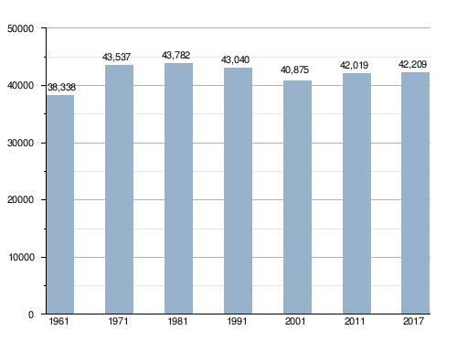
The people from this comune are known, in Italian, as maceratesi.
Twinned towns
[change | change source]Macerata is twinned with:
 Weiden in der Oberpfalz, Germany, since 1963
 Issy-les-Moulineaux, France, since 1982
 Floriana, Malta, since 2007
 Kamëz, Albania, since 13 March 2010[7]
 Sheffield, UK, since 2013
Gallery
[change | change source] Panorama of Macerata
 Piazza della Liberta
 Cathedral of Macerata


References
[change | change source]- ↑ "Il Comune di Macerata- Sindaco" (in Italian). Comune di Macerata. Archived from the original on 20 June 2016. Retrieved 2 July 2016.
- 1 2 "Classificazioni statistiche – anno 2026". www.istat.it. Italian National Institute of Statistics. 2026-02-21. Retrieved 2026-02-27. (Note: The file URL linking to technical dataset.)
- ↑ "Resident population by age, sex and marital status on 1st January 2026". demo.istat.it. Italian National Institute of Statistics. 2026-01-01. Retrieved 2026-04-01. (Note: The file URL linking to technical dataset.)
- ↑ Cite error: The named reference
areawas used but no text was provided for refs named (see the help page). - ↑ "Comuni limitrofi a Macerata" (in Italian). Tuttitalia.it. Retrieved 2 July 2016.
- ↑ Cite error: The named reference
popwas used but no text was provided for refs named (see the help page). - ↑ Binjakëzime Archived 2013-09-21 at the Wayback Machine, Municipality of Kamëz (in Albanian)
Other websites
[change | change source]

- Macerata official website (in Italian)