


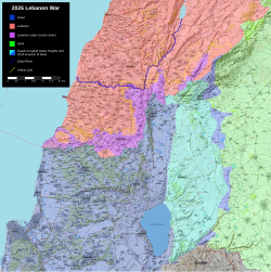
File:2026 Lebanon War Map.svg


Size of this PNG preview of this SVG file: 598 × 600 pixels. Other resolutions: 239 × 240 pixels | 479 × 480 pixels | 766 × 768 pixels | 1,021 × 1,024 pixels | 2,043 × 2,048 pixels | 6,665 × 6,682 pixels.



Original file (SVG file, nominally 6,665 × 6,682 pixels, file size: 9.84 MB)
This is a file from the Wikimedia Commons. Information from its description page there is shown below.
Commons is a freely licensed media file repository. You can help.

Commons is a freely licensed media file repository. You can help.
Summary
| Description |
English: Map of the 2026 Lebanon War. |
| Date | |
| Source |
Derivate of Israel-Lebanon-Syria-border-Conflict-2023.svg by Veggies and Ecrusized. IDF control in Lebanon per the Institute for the Study of War. Post 2024 invasion of Syria per ISW. |
| Author | President Loki |

Licensing
I, the copyright holder of this work, hereby publish it under the following license:


This file is licensed under the Creative Commons Attribution-Share Alike 4.0 International license.
- You are free:
- to share – to copy, distribute and transmit the work
- to remix – to adapt the work
- Under the following conditions:
- attribution – You must give appropriate credit, provide a link to the license, and indicate if changes were made. You may do so in any reasonable manner, but not in any way that suggests the licensor endorses you or your use.
- share alike – If you remix, transform, or build upon the material, you must distribute your contributions under the same or compatible license as the original.
File history
Click on a date/time to view the file as it appeared at that time.


| Date/Time | Thumbnail | Dimensions | User | Comment | |
|---|---|---|---|---|---|
| current | 09:05, 24 May 2026 | | 6,665 × 6,682 (9.84 MB) | Veggies | Removed Hezbollah territory as too nebulous and replaced with Lebanon; map based on ISW map |
| 17:09, 23 April 2026 |  | 6,665 × 6,682 (9.87 MB) | Veggies | Added Yellow Line; changed colors for better visuals | |
| 22:42, 20 April 2026 |  | 6,665 × 6,682 (9.9 MB) | Ecrusized | Fixes | |
| 19:56, 20 April 2026 |  | 6,665 × 6,682 (9.86 MB) | Ecrusized | Update IDF controlled territory in Lebanon per Ben Tzion Machales https://x.com/BenTzionMacales/status/2045927107340206208 | |
| 13:17, 17 April 2026 |  | 6,665 × 6,682 (9.85 MB) | Veggies | Fix minor error | |
| 13:15, 17 April 2026 |  | 6,665 × 6,682 (9.85 MB) | Veggies | Update | |
| 13:04, 16 April 2026 |  | 6,665 × 6,682 (9.85 MB) | Veggies | Update | |
| 18:14, 14 April 2026 |  | 6,665 × 6,682 (9.85 MB) | Veggies | Update | |
| 11:50, 14 April 2026 |  | 6,665 × 6,682 (9.84 MB) | Veggies | Updates | |
| 21:24, 12 April 2026 |  | 6,665 × 6,682 (9.84 MB) | Veggies | Update |
File usage
The following 13 pages use this file:
- 2026 Iran war
- 2026 Lebanon war
- Battle of Bint Jbeil (2026)
- Battle of Haddatha
- Battle of Khiam (2026)
- Hezbollah–Israel conflict (2023–present)
- Israeli-occupied territories
- Israeli occupation of Southern Lebanon (2026)
- Israeli–Lebanese conflict
- List of engagements during the 2026 Lebanon War
- User:Falcaorib/Israel, Palestine and Jordan
- User:Falcaorib/Syria and Lebanon
- Template:Hezbollah–Israel conflict (2023–present) infobox
Global file usage
The following other wikis use this file:
- Usage on bn.wikipedia.org
- Usage on ckb.wikipedia.org
- Usage on de.wikipedia.org
- Usage on el.wikipedia.org
- Usage on es.wikipedia.org
- Usage on fa.wikipedia.org
- Usage on fr.wikipedia.org
- Usage on he.wikipedia.org
- Usage on id.wikipedia.org
- Usage on it.wikipedia.org
- Usage on kk.wikipedia.org
- Usage on my.wikipedia.org
- Usage on no.wikipedia.org
- Usage on ro.wikipedia.org
- Usage on simple.wikipedia.org
- Usage on uk.wikipedia.org
- Usage on zh.wikipedia.org
